Federal Projects:
“NGOMEX 2016: Using Linked Models to Predict the Impacts of Hypoxia on Gulf Coast Fisheries Under Scenarios of Watershed and River Management”. Sponsored by NOAA Center for Sponsored Coastal Ocean Research (NOAA) (2019-2021)
In this project we propose to link a set of models (existing and new) to provide a consistent set of calculations from watershed and river management actions to water quality and hypoxia through population responses for key species. The species are croaker (ecologically important), menhaden (large biomass fishery), and shrimp and red snapper (commercially important).
While our proposed approach has many desirable features, we recognize that it is complicated to link models and be able to perform enough simulations to effectively inform management. For example, as an alternative to linking, one could simply use the existing results of the separate models and try to infer how watershed and diversion actions would affect fish populations. At the other extreme, one could start over and develop a single integrated new model that combines the needed aspects from the existing models. Using existing results leaves the results open to criticism of inconsistencies because unified scenarios and other assumptions and conditions were not maintained across the models. Developing a new integrated model has some good features but is a huge effort that would require re-assessing the new integrated model for its realism. We contend that the existing models are well designed for linked analyses.
We also recognize that the population level is a convenient level to generate predictions because data are available, and fisheries management is based on the population level (unit stock concept) so results relate directly to management. In addition, a focus on a single species enables use of an individual-based modeling approach to simulate realistic exposure to low DO.
Working at levels below the population (e.g., larval stage; annual egg to recruitment) would be easier in model formulation but would not allow for integration of multiple stressors and drivers affecting different life stages. Reporting effects concerning changes in habitat quality (e.g., Zhang et al. 2014), local displacement of individuals (e.g., Craig et al. 2005), number of individuals with reduced fecundity relative to control sites (e.g., Thomas and Rahman 2011), and shifts in food (zooplankton) within the vicinity of the hypoxic zone (Roman et al. 2012) are critical information, but are difficult to use by themselves to determine how much nutrient loadings should be reduced to provide a net ecological benefit and to then justify the economic costs involved in reducing the nutrients.
Ideally, one would work above the population level and deal explicitly with community and food web interactions. However, in our opinion, community and food web modeling is not sufficiently advanced yet (e.g., ongoing debates on predator-prey formulations – DeAngelis 2013) to generate credible predictions of whole food web responses to hypoxia. The uncertainties in specifying the food web structure and interactions likely overwhelm the predictions of the effects in response to changes in hypoxia and prey expected from management actions. Challenges include determining how exposure to low DO that varies over hours leads to effects on bulk biomass state variables for dozens of species. Thus, like fisheries management, we focus on the population level to allow for tractable and defensible simulation of long-term responses relevant to management, recognizing that inter-specific interactions (i.e., food web) continually need to be considered as they may influence the model predictions.
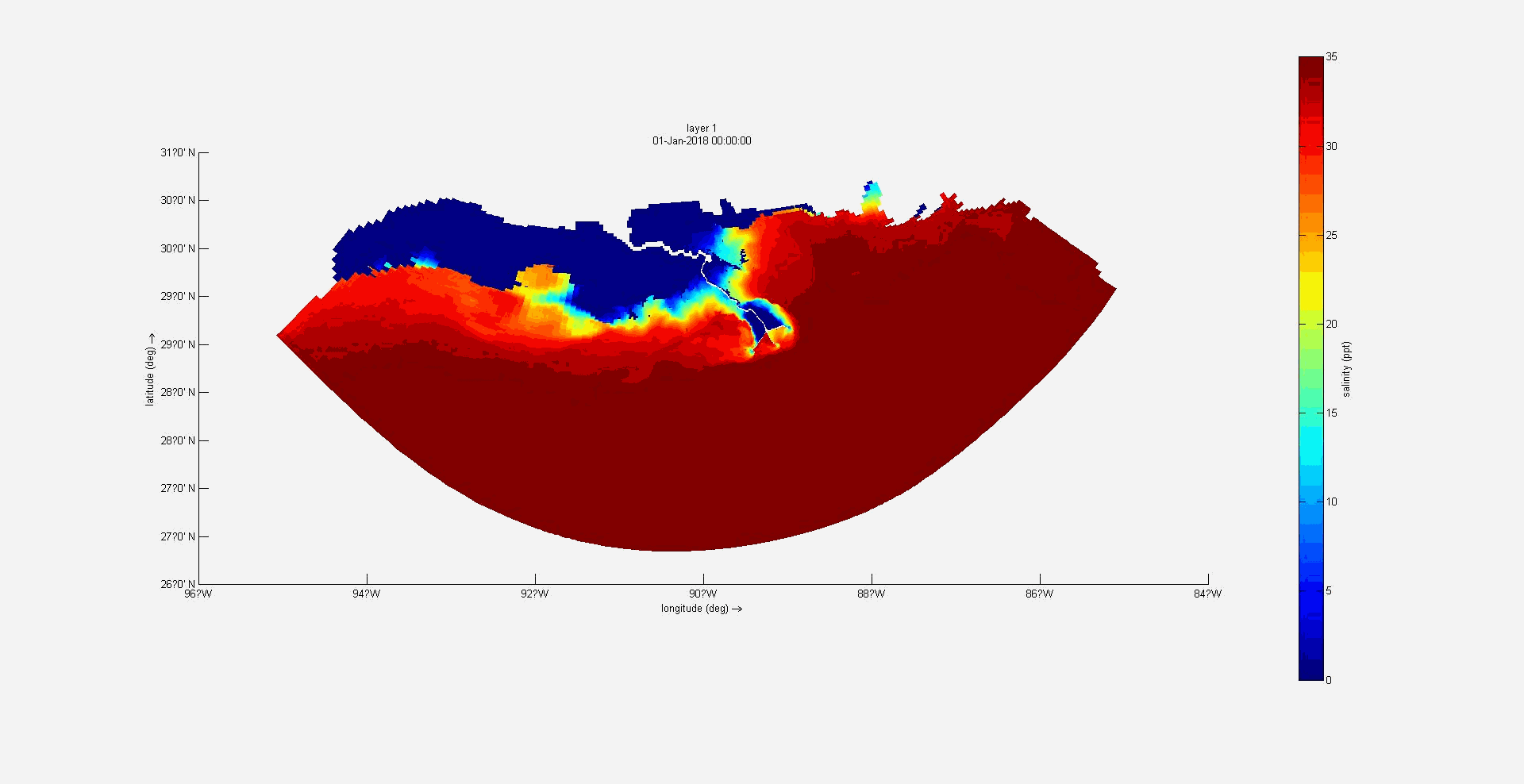
Surface salinity animation in the regional domain
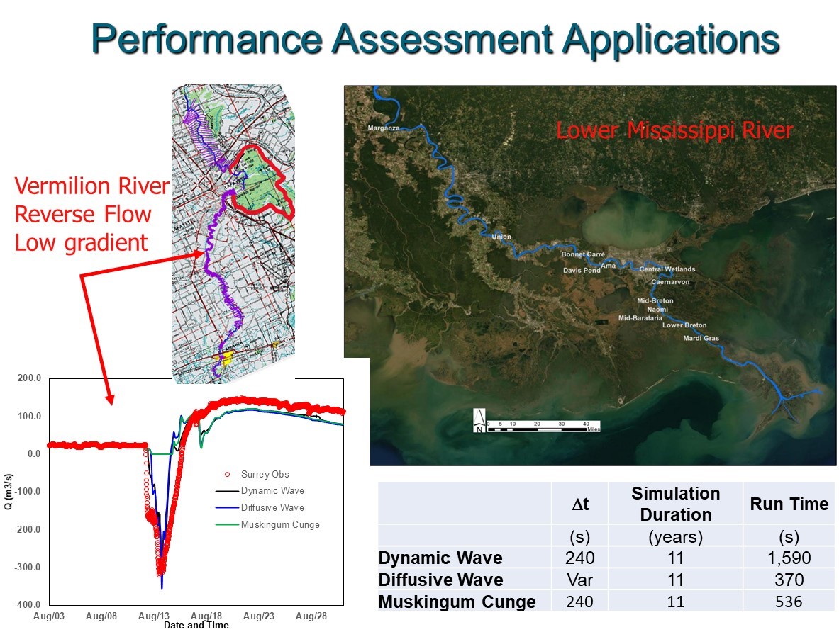
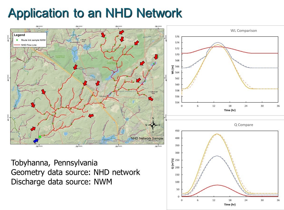
NOAA-Office of Water Prediction: “Implementation of an Accurate, Robust and Computationally Efficient Channel Routing Technique for the National Water Model (NWM)” – (2018 – 2021)
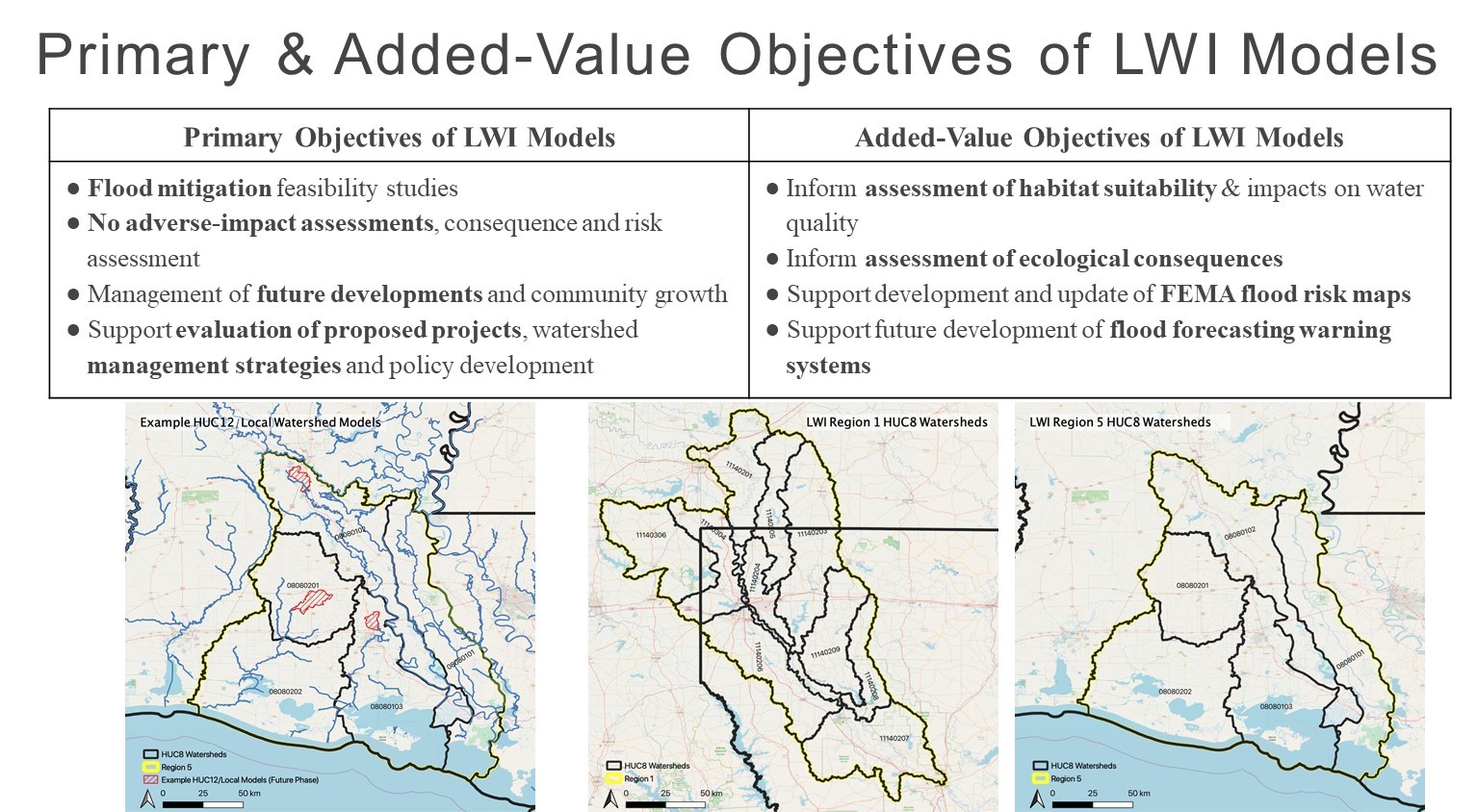
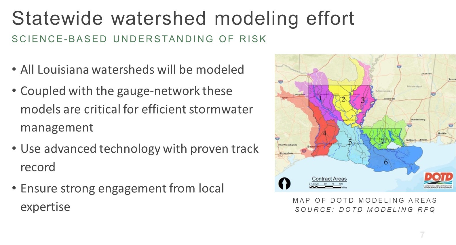
“Louisiana Watershed Initiative.” Sponsored by U.S. Department of Housing and Urban Development (HUD) through Office of Community Development (OCD) – (2018-2021)
The Louisiana Watershed Initiative (LWI: https://www.watershed.la.gov/) is statewide effort to manage future flood risk in Louisiana through watershed-based solutions. The Tulane/UL Lafayette team represent the Technical Design and Quality (TDQ) team supports the initiative for technical matters relevant to the data & modeling components of the program.
State & Private Projects:
(PI) “2023 Coastal Master Plan: Model updates and improvements” (CPRA): (2019-2021)
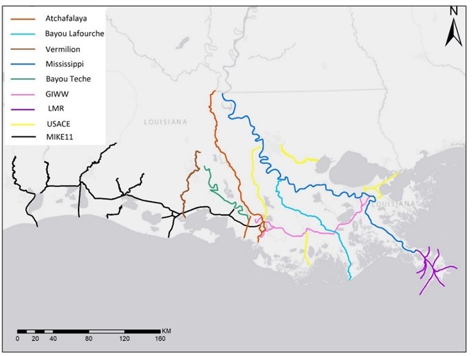
In this project, the Tulane modeling team is supporting the updates and improvements to the Integrated Compartment Model (ICM). The ICM is a landscape model that was used extensively to support the 2017 Louisiana Coastal Master Plan. The updates and improvements are done in preparation for the 2023 Master Plan effort. Dr. Ehab Meselhe will lead the Tulane modeling team for the activities requested by CPRA. The modeling team is working closely with Eric White (CPRA) and other team members under the coordination of the larger CPRA Master Plan team. The color-coded map explicitly includes the names and data sources for different channels modeled as part of the 2023 ICM.
“Optimization of the Bonnet Carré Operation Plans” (EDF) (2019-2021)
Press Release:
In response to an unprecedented four openings of the Bonnet Carré Spillway in the last five years and with the possibility of more climate-driven river floods, a new Tulane University study has demonstrated the efficacy of upper river diversions as a means to improve river management and reduce the volume of water flowing through the spillway. The Bonnet Carré Spillway, located in St. Charles Parish, allows flood waters from the Mississippi River to flow into Lake Pontchartrain and then into the Gulf of Mexico. It has been opened 16 times since its construction in 1937 — four times since March 2018. In 2019, an unprecedented volume of water was released through the structure, nearly 31 million acre-ft (which means that 31 million acres area covered with 1 foot of water). Opening the spillway relieves pressure on levees that protect about one million people in southeast Louisiana from flooding and allows the Corps to maintain river stages and regulate river flow downstream from the spillway.
The Tulane study was conducted by Ehab Meselhe, a professor in the Department of River-Coastal and Science Engineering who helped build numerical models used in Louisiana’s 2012 and 2017 Coastal Master Plans.
He said environmental challenges resulting from the recent and frequent operation of the spillway by the U.S. Army Corps of Engineers underscores the urgency of identifying alternatives to improve river management and confront the new normal of more frequent river floods, including solutions to reduce the magnitude and duration of spillway openings with effects on wildlife, seafood production, coastal communities and economies.
“In 2018, 2019 and 2020, it was the first time ever that the spillway was opened in three consecutive years. And in 2019 it was also the first time ever for the spillway to be opened twice in the same calendar year,” Meselhe said.
“And every time it operates, especially if it operates in the summer or late spring, when temperatures are high, there is an impact on water quality.”
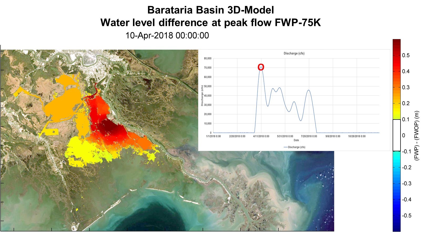
Science indicates that climate change might cause more frequent floods on the Mississippi River, requiring more regular openings of the Bonnet Carré Spillway. To confront this new normal, Restore the Mississippi River Delta, a group of nonprofit conservation organizations asked Meselhe to explore solutions for improving river management that are currently proposed as part of Louisiana’s Coastal Master Plan. Meselhe modeled how three river diversions planned north of the Bonnet Carré Spillway can be operated to relieve pressure and reduce the volume of water flowing through the spillway, while also restoring coastal ecosystems. The organizations include Environmental Defense Fund, which funded the study, along with Lake Pontchartrain Basin Foundation, the National Wildlife Federation, Coalition to Restore Coastal Louisiana, and National Audubon Society.
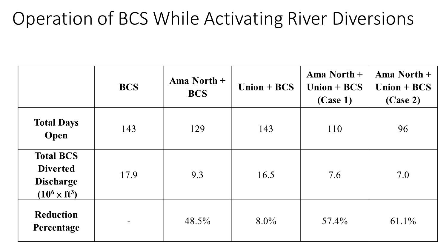
The study — the first of the phases — uses digital models to simulate several diversions as possible flood control outlets. They include Ama North, Ama, Union and River Reintroduction in Lake Maurepas. Due to its small size, Maurepas had little impact but Ama North and Union, both individually and jointly, resulted in a noticeable reduction to the magnitude of the Bonnet Carré pulse.
Specifically, when the Ama North and Union diversions are operated jointly, the reduction in the flow volume released through the BCS ranged between 57 percent and 61 percent, while reducing the duration of the opening from 143 days to 96 days.
The second part of the study will be a basin-side analysis designed to capture and quantify the potential benefits of using the upper river diversions as flood control outlets. The goal of such an analysis will be to examine the impact of the water quality and the potential environmental benefits to the wetlands and estuarine systems.
Ideally, the results of the study will be presented to Congress, which would have to support other scientifically defensible options as possibilities to better manage the river, Meselhe said.
“We completely understand the way the Corps of Engineers operates Bonnet Carré, and this study is not meant in any way at all to criticize the Corps” Meselhe said. “We are simply saying, ‘why not combine flood control objectives with ecosystem restoration opportunities– a win-win.”
“Relationship Between GHG Reduction and SLR Land Loss in Louisiana” (EDF) (2021)
The objective of this project is to evaluate greenhouse gas emission reduction scenarios effects on land loss scenarios: Through analysis and mapping, show the relationship between greenhouse gas emission reduction, sea level rise and coastal restoration in Louisiana. (measured by a report submitted to WFF).
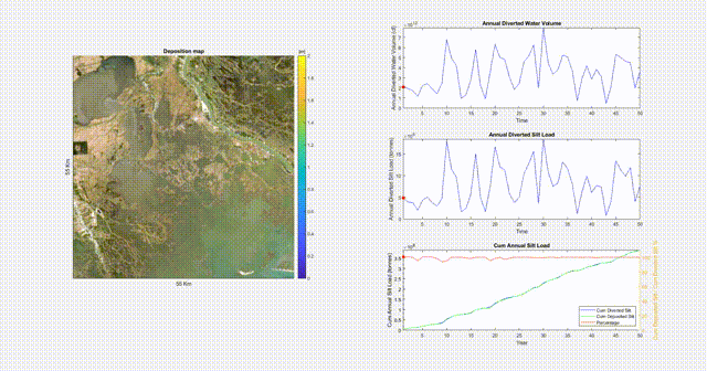
“Quantifying Sediment Retention and Morphologic Evolution in the Fort St. Phillip Crevasse Complex: Implications to Sediment Diversions” Coastal Science Assistantship Program (CSAP) – Louisiana Sea Grant (2021 – 2024)
Sediment diversions represent one of the strategies to help address Louisiana’s rapid coastal land loss. Diversions uniquely restore natural water flow, encourage land building and provide nourishment to existing marshes. This project will use dual observation-modeling approach to improve the understanding of the role stratigraphy plays in the formation and resilience of new and existing wetland areas. This project, collaboratively with Jafari’s project titled “Quantifying Geotechnical Properties and Processes in the Fort St. Phillip Crevasse Complex: Implications to Sediment Diversions,” will focus on the development of numerical models supported and validated by field observations and laboratory testing. The main goal of this project is to reduce uncertainty and optimize the operation strategies of proposed sediment diversions.
“Development of a Decision Support Tool and Data Management System to Identify Relevant Monitoring Metrics for Evaluation and Comparison of Effective Coastal Restoration Activities” (Sea Grant) (2020 – 2022)
In 2006, the Coastwide Reference Monitoring System (CRMS) was established to provide regular observations of wetland conditions at almost 400 sites. And since the first Coastal Master Plan in 2007, many projects have been implemented across Louisiana. However, these two programs haven’t been systematically coupled to understand how the various projects are performing. In connecting these two pieces, Keller will determine new ecosystem and restoration metrics and indices that study the effectiveness of select Coastal Wetlands Planning Protection and Restoration Act sites. While numerous decision support tools exist, this project links data, models and stakeholders more seamlessly, allowing management to determine whether their multiple objectives were met and make more adaptive decisions. In developing comprehensive, quantifiable decision support tools, Keller hopes to improve the design and implementation of future projects throughout the state.
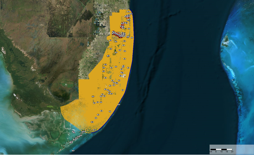
The D-FLOW flexible mesh for the Biscayne Bay Coastal Areas